IMAGES TAKEN NEAR TO
Forgue, HUNTLY, AB54 6BW
Introduction
This page details the photographs taken nearby to AB54 6BW by members of the Geograph project.
The Geograph project started in 2005 with the aim of publishing, organising and preserving representative images for every square kilometre of Great Britain, Ireland and the Isle of Man.

There are currently over 7.5m images from over14,400 individuals and you can help contribute to the project by visiting https://www.geograph.org.uk
Image Map
Images are licensed for reuse under creativecommons.org/licenses/by-sa/2.0
Notes
- Clicking on the map will re-center to the selected point.
- The higher the marker number, the further away the image location is from the centre of the postcode.
Image Listing (5 Images Found)
Images are licensed for reuse under creativecommons.org/licenses/by-sa/2.0
Image
Details
Distance
2
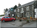
Bognie Arms
Hotel on the A97 north of Huntly.
Image: © James Allan
Taken: 30 Nov 2006
0.23 miles
3
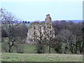
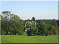
Conzie Castle
There's little left of this building which sits astride the OS square line, but the wall seen here is definitely just inside NJ5944. Also known locally as Bognie Castle, little is known about its history. It was probably built between 1660 and 1670 by the Morrisons. No signs remain of any vaulted ceilings or even room divisions.
Image: © James Allan
Taken: 30 Nov 2006
0.25 miles