IMAGES TAKEN NEAR TO
Forgue, HUNTLY, AB54 6BS
Introduction
This page details the photographs taken nearby to AB54 6BS by members of the Geograph project.
The Geograph project started in 2005 with the aim of publishing, organising and preserving representative images for every square kilometre of Great Britain, Ireland and the Isle of Man.

There are currently over 7.5m images from over14,400 individuals and you can help contribute to the project by visiting https://www.geograph.org.uk
Image Map
Images are licensed for reuse under creativecommons.org/licenses/by-sa/2.0
Notes
- Clicking on the map will re-center to the selected point.
- The higher the marker number, the further away the image location is from the centre of the postcode.
Image Listing (5 Images Found)
Images are licensed for reuse under creativecommons.org/licenses/by-sa/2.0
Image
Details
Distance
1

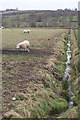
Kirkland Farm
Contrary to appearances, the sheep and lamb are not perching on the fence post. They were in fact trotting towards me, which is a bit disconcerting as most sheep tend to do the exact opposite when a camera is brandished toward them.
Image: © Anne Burgess
Taken: 27 Feb 2015
0.02 miles
3
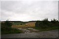
Bales by Muirton
A baled field by Mid Muirton.
Image: © Andrew Wood
Taken: 12 Sep 2011
0.20 miles
4
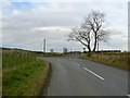
Bare trees by the junction
Right fork to Banff or left to Huntly.
Image: © James Allan
Taken: 30 Nov 2006
0.21 miles
5
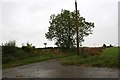
Mid Muirton
The access road to Mid Muirton.
Image: © Andrew Wood
Taken: 12 Sep 2011
0.23 miles