IMAGES TAKEN NEAR TO
Forgue, HUNTLY, AB54 6BN
Introduction
This page details the photographs taken nearby to AB54 6BN by members of the Geograph project.
The Geograph project started in 2005 with the aim of publishing, organising and preserving representative images for every square kilometre of Great Britain, Ireland and the Isle of Man.

There are currently over 7.5m images from over14,400 individuals and you can help contribute to the project by visiting https://www.geograph.org.uk
Image Map
Images are licensed for reuse under creativecommons.org/licenses/by-sa/2.0
Notes
- Clicking on the map will re-center to the selected point.
- The higher the marker number, the further away the image location is from the centre of the postcode.
Image Listing (3 Images Found)
Images are licensed for reuse under creativecommons.org/licenses/by-sa/2.0
Image
Details
Distance
1
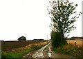
Pitfancy Farm
Pitfancy at the end of its access road.
Image: © Andrew Wood
Taken: 12 Sep 2011
0.12 miles
2
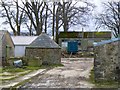
Circular farm building
An unusual circular building with a conical roof in Pitfancy farmyard.
Image: © James Allan
Taken: 30 Nov 2006
0.19 miles
3
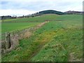
Four fields, four shades of green
Rolling agricultural land with Cruchie Wood in the background.
Image: © James Allan
Taken: 30 Nov 2006
0.24 miles