IMAGES TAKEN NEAR TO
Forgue, HUNTLY, AB54 6BL
Introduction
This page details the photographs taken nearby to AB54 6BL by members of the Geograph project.
The Geograph project started in 2005 with the aim of publishing, organising and preserving representative images for every square kilometre of Great Britain, Ireland and the Isle of Man.

There are currently over 7.5m images from over14,400 individuals and you can help contribute to the project by visiting https://www.geograph.org.uk
Image Map
Images are licensed for reuse under creativecommons.org/licenses/by-sa/2.0
Notes
- Clicking on the map will re-center to the selected point.
- The higher the marker number, the further away the image location is from the centre of the postcode.
Image Listing (3 Images Found)
Images are licensed for reuse under creativecommons.org/licenses/by-sa/2.0
Image
Details
Distance
1
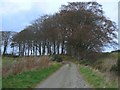
Going round the bend
The road to Cairnton takes a sharp swing to the left here.
Image: © James Allan
Taken: 30 Nov 2006
0.12 miles
2
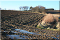
Near Cairnton
Frozen water fills the ruts at the bottom of this field beside the track up to Cairnton. The conifers at the top of the brae are part of Cobairdy Wood.
Image: © Anne Burgess
Taken: 11 Feb 2015
0.15 miles
3
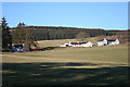
Cairnton Cottages
Beautifully situated a little distance up the hillside, with shelter from the north and an open southerly aspect and view.
Image: © Anne Burgess
Taken: 11 Feb 2015
0.19 miles