IMAGES TAKEN NEAR TO
Drumblade, HUNTLY, AB54 6BJ
Introduction
This page details the photographs taken nearby to AB54 6BJ by members of the Geograph project.
The Geograph project started in 2005 with the aim of publishing, organising and preserving representative images for every square kilometre of Great Britain, Ireland and the Isle of Man.

There are currently over 7.5m images from over14,400 individuals and you can help contribute to the project by visiting https://www.geograph.org.uk
Image Map
Images are licensed for reuse under creativecommons.org/licenses/by-sa/2.0
Notes
- Clicking on the map will re-center to the selected point.
- The higher the marker number, the further away the image location is from the centre of the postcode.
Image Listing (7 Images Found)
Images are licensed for reuse under creativecommons.org/licenses/by-sa/2.0
Image
Details
Distance
1
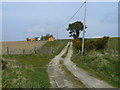
House with stables at Drumdollo
On a crest of land near the Mains of Drumdollo.
Image: © Jonathan Billinger
Taken: 22 Apr 2008
0.00 miles
2

Cottown of Drumdollo
A brief spell of sunshine illuminates Cottown of Drumdollo and the neighbouring fields of barley.
Image: © Anne Burgess
Taken: 19 Sep 2008
0.01 miles
3
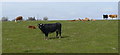
Beef cattle at Drumdollo
Spring pastures south of Cottown.
Image: © Jonathan Billinger
Taken: 22 Apr 2008
0.07 miles
4
Cultivating the land
Arable land west of the road at Drumdollo. This is the same burn as in Image
Image: © Jonathan Billinger
Taken: 22 Apr 2008
0.10 miles
5
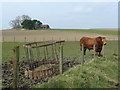
Bull at Drumdollo
Looking west from the road towards some farm buildings in the next gridsquare.
Image: © Jonathan Billinger
Taken: 22 Apr 2008
0.17 miles
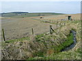
6
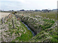
Mains of Drumdollo
View east, upstream of the burn which flows past the farm in this area of mixed arable and pasture.
Image: © Jonathan Billinger
Taken: 22 Apr 2008
0.18 miles
7

Moss-side of Drumdollo
There seem to be two or three places sharing the same name here.
Image: © Anne Burgess
Taken: 19 Sep 2008
0.21 miles