IMAGES TAKEN NEAR TO
Ythanwells, HUNTLY, AB54 6BD
Introduction
This page details the photographs taken nearby to AB54 6BD by members of the Geograph project.
The Geograph project started in 2005 with the aim of publishing, organising and preserving representative images for every square kilometre of Great Britain, Ireland and the Isle of Man.

There are currently over 7.5m images from over14,400 individuals and you can help contribute to the project by visiting https://www.geograph.org.uk
Image Map
Images are licensed for reuse under creativecommons.org/licenses/by-sa/2.0
Notes
- Clicking on the map will re-center to the selected point.
- The higher the marker number, the further away the image location is from the centre of the postcode.
Image Listing (7 Images Found)
Images are licensed for reuse under creativecommons.org/licenses/by-sa/2.0
Image
Details
Distance
1
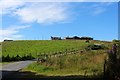
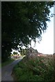
Aultdavie Farm
Aultdavie at the top of a small hill near Hassiewells.
Image: © Andrew Wood
Taken: 16 Aug 2020
0.11 miles
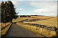
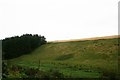
3
Looking up the hill...
...towards Aultdavie farm
Image: © Bill Harrison
Taken: 7 Apr 2019
0.11 miles
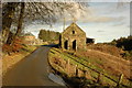
5
Glenmellan Barn
An old barn at the hill farm of Glenmellan.
Image: © Andrew Wood
Taken: 17 Aug 2011
0.18 miles
6
Banks of the Ythan
The banks of the young River Ythan at Glenmellan.On the top of the bank just out of sight is a Roman Camp.
Image: © Andrew Wood
Taken: 12 Sep 2011
0.21 miles
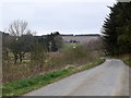
7
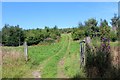
Woodland Track
A woodland track near Hassiewells.
Image: © Andrew Wood
Taken: 16 Aug 2020
0.22 miles