IMAGES TAKEN NEAR TO
HUNTLY, AB54 6AU
Introduction
This page details the photographs taken nearby to AB54 6AU by members of the Geograph project.
The Geograph project started in 2005 with the aim of publishing, organising and preserving representative images for every square kilometre of Great Britain, Ireland and the Isle of Man.

There are currently over 7.5m images from over14,400 individuals and you can help contribute to the project by visiting https://www.geograph.org.uk
Image Map
Images are licensed for reuse under creativecommons.org/licenses/by-sa/2.0
Notes
- Clicking on the map will re-center to the selected point.
- The higher the marker number, the further away the image location is from the centre of the postcode.
Image Listing (9 Images Found)
Images are licensed for reuse under creativecommons.org/licenses/by-sa/2.0
Image
Details
Distance
1
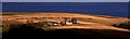
Auchintender
Dramatic winter sunshine illuminates a farm at the east end of the notorious Glens of Foudland
Image: © Anne Burgess
Taken: Unknown
0.03 miles
2
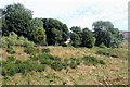
Auchintender in Woodland
A glimpse of Auchintender through sheltering trees.
Image: © Andrew Wood
Taken: 16 Aug 2020
0.07 miles
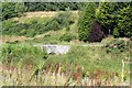
3
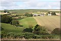
Auchintender
The gridline passes through the buildings at Auchintender, beautifully situated on the slopes above the Mill Burn.
Image: © Anne Burgess
Taken: 22 Sep 2008
0.07 miles
4
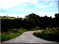
Road to Auchintender
From road junction near Mill Burn.
Image: © Stanley Howe
Taken: 20 Sep 2007
0.11 miles
5
Bridge over Mill Burn
Near Auchintender.
Image: © Stanley Howe
Taken: 20 Sep 2007
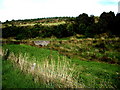
0.12 miles
6
Auchintender Bridge
A road bridge over the Mill Burn by Auchintender.
Image: © Andrew Wood
Taken: 16 Aug 2020
0.12 miles
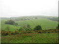
7
View up Mill Burn
From the layby on A96, to north of Hill of Skares.
Image: © Stanley Howe
Taken: 20 Sep 2008
0.21 miles
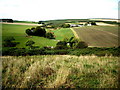
8
Farmland near Fordmouth
On a rather dull day.
Image: © David Purchase
Taken: 12 Jun 2019
0.24 miles
9
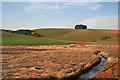
Glen Water
The Glen Water is a headwater of the River Urie. It is joined by the Mill Burn a few hundred metres downstream from here.
Image: © Anne Burgess
Taken: 9 Apr 2015
0.25 miles