IMAGES TAKEN NEAR TO
Bainshole, HUNTLY, AB54 6AQ
Introduction
This page details the photographs taken nearby to AB54 6AQ by members of the Geograph project.
The Geograph project started in 2005 with the aim of publishing, organising and preserving representative images for every square kilometre of Great Britain, Ireland and the Isle of Man.

There are currently over 7.5m images from over14,400 individuals and you can help contribute to the project by visiting https://www.geograph.org.uk
Image Map
Images are licensed for reuse under creativecommons.org/licenses/by-sa/2.0
Notes
- Clicking on the map will re-center to the selected point.
- The higher the marker number, the further away the image location is from the centre of the postcode.
Image Listing (6 Images Found)
Images are licensed for reuse under creativecommons.org/licenses/by-sa/2.0
Image
Details
Distance
1
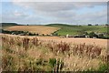
Stodfold, Clinkstone and Broomhill
Three farms just west of the Glens of Foudland. In the background is the Newtongarry wind farm.
Image: © Anne Burgess
Taken: 22 Sep 2008
0.01 miles
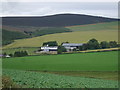
3
Field of cattle beside the A96
Broomhill Farm is beyond the field , but unseen, as it is down beside the Glen Water ( heading for the Glens of Foudland ). In the photo are Clinkstone and Stodfields. Sorry for the raindrop, but the remains of hurricane Katia are arriving.
Image: © Peter Aikman
Taken: 12 Sep 2011
0.18 miles
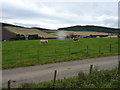
5
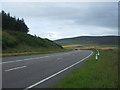
A bend in the A96, Broom Hill
Heading south east towards Aberdeen.
Image: © JThomas
Taken: 20 Jul 2014
0.24 miles
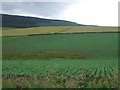
6
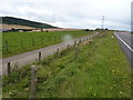
Farm track servicing the field beside the busy A96
It was probably put in when the A96 was widened.
Image: © Peter Aikman
Taken: 12 Sep 2011
0.24 miles