IMAGES TAKEN NEAR TO
Glass, HUNTLY, AB54 4YP
Introduction
This page details the photographs taken nearby to AB54 4YP by members of the Geograph project.
The Geograph project started in 2005 with the aim of publishing, organising and preserving representative images for every square kilometre of Great Britain, Ireland and the Isle of Man.

There are currently over 7.5m images from over14,400 individuals and you can help contribute to the project by visiting https://www.geograph.org.uk
Image Map
Images are licensed for reuse under creativecommons.org/licenses/by-sa/2.0
Notes
- Clicking on the map will re-center to the selected point.
- The higher the marker number, the further away the image location is from the centre of the postcode.
Image Listing (33 Images Found)
Images are licensed for reuse under creativecommons.org/licenses/by-sa/2.0
Image
Details
Distance
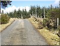
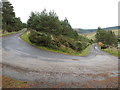
4
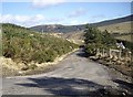
Descent to Lynebain
Below a hairpin bend in the road.
Image: © Stanley Howe
Taken: 10 Mar 2009
0.05 miles
5
Ascent from Lynebain
With a cock pheasant assessing its escape route through a close-mesh fence!
Image: © Stanley Howe
Taken: 10 Mar 2009
0.10 miles
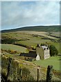
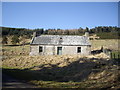
6
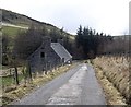
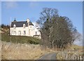
Road down to Mill of Lynebain
Old millhouse ahead.
Image: © Stanley Howe
Taken: 10 Mar 2009
0.11 miles
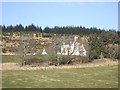
8
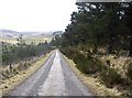
A run down towards Lynebain
With mature firs to the right; and a recent plantation to the left.
Image: © Stanley Howe
Taken: 10 Mar 2009
0.12 miles
9
Minor road to or from Lynebain
Looking north-eastward.
Image: © Peter Wood
Taken: 21 Oct 2018
0.13 miles
10
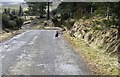
Approach to a hairpin bend
On road down to Lynebain; with a ring-neck cock pheasant on sentry duty.
Image: © Stanley Howe
Taken: 10 Mar 2009
0.13 miles