IMAGES TAKEN NEAR TO
Glass, HUNTLY, AB54 4XR
Introduction
This page details the photographs taken nearby to AB54 4XR by members of the Geograph project.
The Geograph project started in 2005 with the aim of publishing, organising and preserving representative images for every square kilometre of Great Britain, Ireland and the Isle of Man.

There are currently over 7.5m images from over14,400 individuals and you can help contribute to the project by visiting https://www.geograph.org.uk
Image Map
Images are licensed for reuse under creativecommons.org/licenses/by-sa/2.0
Notes
- Clicking on the map will re-center to the selected point.
- The higher the marker number, the further away the image location is from the centre of the postcode.
Image Listing (6 Images Found)
Images are licensed for reuse under creativecommons.org/licenses/by-sa/2.0
Image
Details
Distance
1
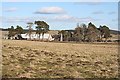
Easter Bodilare
There is a lack of unanimity about the spelling of this place - it also occurs as Bodylair. Moles have evidently been active here this winter past.
Image: © Anne Burgess
Taken: 6 Mar 2009
0.01 miles
2
Easter Bodilare
From Braehead road junction.
Image: © Stanley Howe
Taken: 21 Mar 2009
0.02 miles
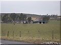
3
Easter Bodylair
With Talnamounth [NJ4040; 379m] in rear. Note that some maps show farm as Bodilare (sic).
Image: © Stanley Howe
Taken: 26 Mar 2007
0.03 miles
4
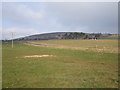
Forest Operations
Looking SE from position
Image: © Iain Macaulay
Taken: 13 Dec 2005
0.06 miles
5
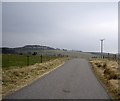
Junction of Braehead road with A920
Near Market Hill.
Image: © Stanley Howe
Taken: 21 Mar 2009
0.21 miles
6
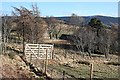
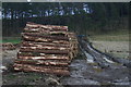
Wester Bodylair
Sheltering trees make it difficult to see the house and steading here from the roadside. The gate is very new, and gives access to an irregularly shaped area recently fenced against deer. There are several blocks of broadleaved tree plantation nearby, so I would surmise that this too is to become a new plantation.
Image: © Anne Burgess
Taken: 6 Mar 2009
0.23 miles