IMAGES TAKEN NEAR TO
Glass, HUNTLY, AB54 4XN
Introduction
This page details the photographs taken nearby to AB54 4XN by members of the Geograph project.
The Geograph project started in 2005 with the aim of publishing, organising and preserving representative images for every square kilometre of Great Britain, Ireland and the Isle of Man.

There are currently over 7.5m images from over14,400 individuals and you can help contribute to the project by visiting https://www.geograph.org.uk
Image Map
Images are licensed for reuse under creativecommons.org/licenses/by-sa/2.0
Notes
- Clicking on the map will re-center to the selected point.
- The higher the marker number, the further away the image location is from the centre of the postcode.
Image Listing (12 Images Found)
Images are licensed for reuse under creativecommons.org/licenses/by-sa/2.0
Image
Details
Distance
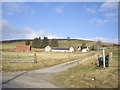
2
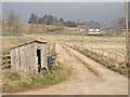
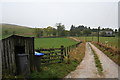
Belnaboth
The farm is set quite well back from the main road.
Image: © Anne Burgess
Taken: 6 Mar 2009
0.05 miles
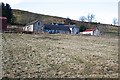
4
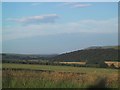
Pasture by Belnaboth
Grassland by Belnaboth under Both Hill.
Image: © Andrew Wood
Taken: 29 Jul 2011
0.18 miles
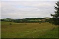
7
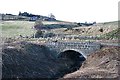
Bridge near Parkhall
The bridge is on a section of the old road, bypassed when the A920 was realigned. It crosses the burn which drains Brownhill and the Daugh of Cairnborrow. Parkhall is on the grid line; the house is in this square and the steading in the next one.
Image: © Anne Burgess
Taken: 6 Mar 2009
0.23 miles
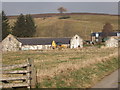
8
Parkhall
Seen from access to Cairnbarrow Lodge.
Image: © Stanley Howe
Taken: 21 Mar 2009
0.23 miles
10
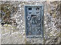
Ordnance Survey Flush Bracket 11890
This bracket can be found on the wall of one of the buildings at Easter Boghead. The benchmark height is recorded as being 208.746 metres above sea level.
For more detail see : https://www.bench-marks.org.uk/bm22649
Image: © Peter Wood
Taken: 21 Oct 2018
0.23 miles