IMAGES TAKEN NEAR TO
Markethill, HUNTLY, AB54 4XE
Introduction
This page details the photographs taken nearby to Markethill, AB54 4XE by members of the Geograph project.
The Geograph project started in 2005 with the aim of publishing, organising and preserving representative images for every square kilometre of Great Britain, Ireland and the Isle of Man.

There are currently over 7.5m images from over14,400 individuals and you can help contribute to the project by visiting https://www.geograph.org.uk
Image Map
Images are licensed for reuse under creativecommons.org/licenses/by-sa/2.0
Notes
- Clicking on the map will re-center to the selected point.
- The higher the marker number, the further away the image location is from the centre of the postcode.
Image Listing (22 Images Found)
Images are licensed for reuse under creativecommons.org/licenses/by-sa/2.0
Image
Details
Distance
1
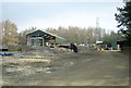
A new workshop near Glass
Function? Pipe coating?
Image: © Stanley Howe
Taken: 21 Mar 2009
0.02 miles
2
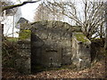
Drinking trough by Glass
Inscribed "A,G. May 3rd 1891" - a Gordon bequest perhaps?
Image: © Stanley Howe
Taken: 21 Mar 2009
0.02 miles
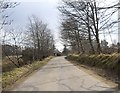
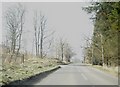
3
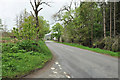
Minor road from A920 to Invermarkie
Looking south-westward.
Image: © Peter Wood
Taken: 21 Oct 2018
0.06 miles
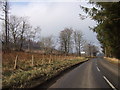
4
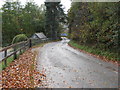
Approach to 'The Bungalow'
On road to Haugh of Glass from A920 by Springfield.
Image: © Stanley Howe
Taken: 21 Mar 2009
0.07 miles
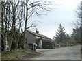
6
Junction for Glass School
Off A920 eastbound.
Image: © Stanley Howe
Taken: 21 Mar 2009
0.11 miles
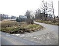
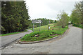
8
Road junction near Springfield
From A920 to Haugh of Glass and Cabrach.
Image: © Stanley Howe
Taken: 21 Mar 2009
0.11 miles
9
Junction of the A920 and road to the Cabrach
Image: © Steven Brown
Taken: 23 May 2010
0.11 miles