IMAGES TAKEN NEAR TO
Glass, HUNTLY, AB54 4XD
Introduction
This page details the photographs taken nearby to AB54 4XD by members of the Geograph project.
The Geograph project started in 2005 with the aim of publishing, organising and preserving representative images for every square kilometre of Great Britain, Ireland and the Isle of Man.

There are currently over 7.5m images from over14,400 individuals and you can help contribute to the project by visiting https://www.geograph.org.uk
Image Map
Images are licensed for reuse under creativecommons.org/licenses/by-sa/2.0
Notes
- Clicking on the map will re-center to the selected point.
- The higher the marker number, the further away the image location is from the centre of the postcode.
Image Listing (8 Images Found)
Images are licensed for reuse under creativecommons.org/licenses/by-sa/2.0
Image
Details
Distance
1
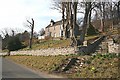
South Manse
The 18th century manse stands above the road, with a splendid view south along the River Deveron.
Image: © Anne Burgess
Taken: 2 Apr 2009
0.01 miles
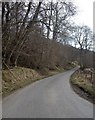
2
View to South Manse
From road by Edinglassie Lodge.
Image: © Stanley Howe
Taken: 19 Mar 2009
0.02 miles
3
Across to South Manse
Fields from the lower slopes of Dumeath to the old south manse of Glass.
Image: © Andrew Wood
Taken: 23 Jul 2010
0.02 miles
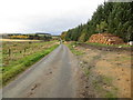
4
Road to Playlands
From near Parkhaugh.
Image: © Stanley Howe
Taken: 19 Mar 2009
0.20 miles
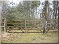
5
Minor road between Playlands and South Manse
Looking north-westward. The lumber awaiting onward transport will have come from the woodland on Straithinnan Moor.
Image: © Peter Wood
Taken: 21 Oct 2018
0.21 miles
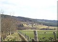
6
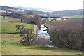
River Deveron
North of Beldorney the glen opens out into a strath. The river winds its way between fertile fields and mature woodlands.
Image: © Anne Burgess
Taken: 2 Apr 2009
0.22 miles
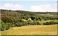
7
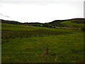
Rough pasture land, Strathbogie
Looking south west, up the valley of the River Deveron.
Image: © Peter Barr
Taken: 12 Sep 2011
0.22 miles