IMAGES TAKEN NEAR TO
Cairnie, HUNTLY, AB54 4UT
Introduction
This page details the photographs taken nearby to AB54 4UT by members of the Geograph project.
The Geograph project started in 2005 with the aim of publishing, organising and preserving representative images for every square kilometre of Great Britain, Ireland and the Isle of Man.

There are currently over 7.5m images from over14,400 individuals and you can help contribute to the project by visiting https://www.geograph.org.uk
Image Map
Images are licensed for reuse under creativecommons.org/licenses/by-sa/2.0
Notes
- Clicking on the map will re-center to the selected point.
- The higher the marker number, the further away the image location is from the centre of the postcode.
Image Listing (7 Images Found)
Images are licensed for reuse under creativecommons.org/licenses/by-sa/2.0
Image
Details
Distance
3
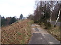
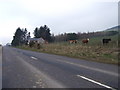
Approach to Milton of Cairnborrow
Along an old section of the A920 (new road to the right).
Image: © Stanley Howe
Taken: 26 Mar 2007
0.13 miles
4
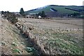
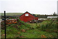
Milton of Cairnborrow
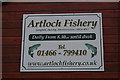
Snowdrops on the A920 embankment provide a seasonal foreground for this view of Milton of Cairnborrow, where heaps of dung await the muck-spreader To the right there is a glimpse of the fishing pond at Artloch, and Clashmach Hill is on the skyline.
Image: © Anne Burgess
Taken: 6 Mar 2009
0.14 miles
5
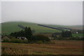
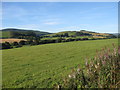
Milton of Cairnborrow on the left, Mains of Artloch to the right.
Image: © Des Colhoun
Taken: 25 Oct 2006
0.16 miles