IMAGES TAKEN NEAR TO
HUNTLY, AB54 4UQ
Introduction
This page details the photographs taken nearby to AB54 4UQ by members of the Geograph project.
The Geograph project started in 2005 with the aim of publishing, organising and preserving representative images for every square kilometre of Great Britain, Ireland and the Isle of Man.

There are currently over 7.5m images from over14,400 individuals and you can help contribute to the project by visiting https://www.geograph.org.uk
Image Map
Images are licensed for reuse under creativecommons.org/licenses/by-sa/2.0
Notes
- Clicking on the map will re-center to the selected point.
- The higher the marker number, the further away the image location is from the centre of the postcode.
Image Listing (4 Images Found)
Images are licensed for reuse under creativecommons.org/licenses/by-sa/2.0
Image
Details
Distance
1
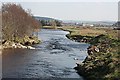
River Deveron
If you look carefully you can just make out an angler standing on the right bank where it justs into the water a few tens of metres downstream. In the background are the outskirts of Huntly including a supermarket.
Image: © Anne Burgess
Taken: 2 Apr 2009
0.09 miles
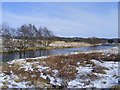
3
Huntly fishing beat
River Deveron by A920 Huntly to Dufftown road.
Image: © Stanley Howe
Taken: 26 Mar 2007
0.23 miles
4
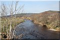
River Deveron
Looking upstream, with Boddum Hill in the right background and The Bin in the distance.
Image: © Anne Burgess
Taken: 2 Apr 2009
0.25 miles