IMAGES TAKEN NEAR TO
HUNTLY, AB54 4UP
Introduction
This page details the photographs taken nearby to AB54 4UP by members of the Geograph project.
The Geograph project started in 2005 with the aim of publishing, organising and preserving representative images for every square kilometre of Great Britain, Ireland and the Isle of Man.

There are currently over 7.5m images from over14,400 individuals and you can help contribute to the project by visiting https://www.geograph.org.uk
Image Map
Images are licensed for reuse under creativecommons.org/licenses/by-sa/2.0
Notes
- Clicking on the map will re-center to the selected point.
- The higher the marker number, the further away the image location is from the centre of the postcode.
Image Listing (28 Images Found)
Images are licensed for reuse under creativecommons.org/licenses/by-sa/2.0
Image
Details
Distance
1
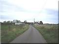
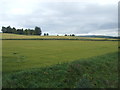
Approach to Milton
Also spelled Milltown on OS OpenSpace.
Image: © Stanley Howe
Taken: 26 Sep 2011
0.04 miles
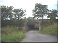
3
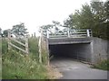
Milton underpass seen from the west
A farm road under the A96 road.
Image: © Stanley Howe
Taken: 26 Sep 2011
0.09 miles
6
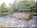
Forest flotsam in the River Deveron
Tree branch aground below the Bridge of Gibston, following recent gale-force (tail-end of hurricane) winds in Scotland.
Image: © Stanley Howe
Taken: 26 Sep 2011
0.11 miles
9
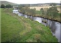
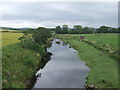
'The Mermaid' reach of the River Deveron
Between the Bridge of Gibston (viewpoint) and the A96 road bridge upstream.
Image: © Stanley Howe
Taken: 26 Sep 2011
0.13 miles
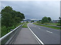
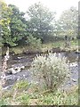
10
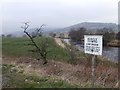
Huntly fishing beat
River Deveron by A920 Huntly to Dufftown road.
Image: © Stanley Howe
Taken: 26 Mar 2007
0.14 miles