IMAGES TAKEN NEAR TO
Cairnie, HUNTLY, AB54 4UE
Introduction
This page details the photographs taken nearby to AB54 4UE by members of the Geograph project.
The Geograph project started in 2005 with the aim of publishing, organising and preserving representative images for every square kilometre of Great Britain, Ireland and the Isle of Man.

There are currently over 7.5m images from over14,400 individuals and you can help contribute to the project by visiting https://www.geograph.org.uk
Image Map
Images are licensed for reuse under creativecommons.org/licenses/by-sa/2.0
Notes
- Clicking on the map will re-center to the selected point.
- The higher the marker number, the further away the image location is from the centre of the postcode.
Image Listing (4 Images Found)
Images are licensed for reuse under creativecommons.org/licenses/by-sa/2.0
Image
Details
Distance
2
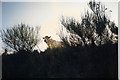
Track from Smallburn
Looking back towards Smallburn from the track which I am told leads over Ba Muir to Cairnborrow.
Image: © Anne Burgess
Taken: 13 Feb 2008
0.13 miles
3
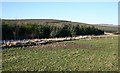
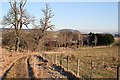
Smallburn
These fields by the edge of the forest above Smallburn are evidently grazed by cattle, though none were in evidence today.
Image: © Anne Burgess
Taken: 13 Feb 2008
0.19 miles
4
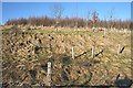
Smallburn
Broadleaf planting by the Small Burn will eventually screen the conifer forest from view from the track.
Image: © Anne Burgess
Taken: 13 Feb 2008
0.22 miles