IMAGES TAKEN NEAR TO
Cairnie, HUNTLY, AB54 4UA
Introduction
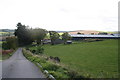
This page details the photographs taken nearby to AB54 4UA by members of the Geograph project.
The Geograph project started in 2005 with the aim of publishing, organising and preserving representative images for every square kilometre of Great Britain, Ireland and the Isle of Man.

There are currently over 7.5m images from over14,400 individuals and you can help contribute to the project by visiting https://www.geograph.org.uk
Image Map
Images are licensed for reuse under creativecommons.org/licenses/by-sa/2.0
Notes
- Clicking on the map will re-center to the selected point.
- The higher the marker number, the further away the image location is from the centre of the postcode.
Image Listing (11 Images Found)
Images are licensed for reuse under creativecommons.org/licenses/by-sa/2.0
Image
Details
Distance
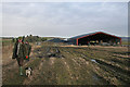
5
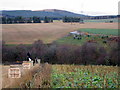
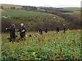
"Flags" on the Burnside drive
While the beaters and their dogs hunt through the gamecrop two "flaggers" can be seen and once a flush of birds get airborne they are coaxed over the guns by the flags.
Image: © Des Colhoun
Taken: 14 Nov 2018
0.13 miles
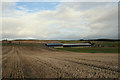
9
The Burnside drive discussed
Beaters discuss the success of the drive here at the Burnside farm.
Image: © Des Colhoun
Taken: 14 Nov 2018
0.24 miles
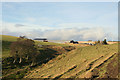
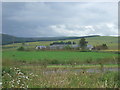
10
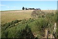
Easter Auchairn
Looking up from the minor road above Bridge of Ardonald.
Image: © Anne Burgess
Taken: 4 Feb 2008
0.24 miles