IMAGES TAKEN NEAR TO
Cairnie, HUNTLY, AB54 4TQ
Introduction
This page details the photographs taken nearby to AB54 4TQ by members of the Geograph project.
The Geograph project started in 2005 with the aim of publishing, organising and preserving representative images for every square kilometre of Great Britain, Ireland and the Isle of Man.

There are currently over 7.5m images from over14,400 individuals and you can help contribute to the project by visiting https://www.geograph.org.uk
Image Map
Images are licensed for reuse under creativecommons.org/licenses/by-sa/2.0
Notes
- Clicking on the map will re-center to the selected point.
- The higher the marker number, the further away the image location is from the centre of the postcode.
Image Listing (11 Images Found)
Images are licensed for reuse under creativecommons.org/licenses/by-sa/2.0
Image
Details
Distance
1
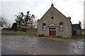
War Memorial Hall
Built in Cairnie to commemorate the fallen of the Great War (1914-1918).
Image: © John Allan
Taken: 5 Feb 2007
0.01 miles
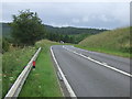
2
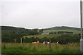
Above Cairnie
Cattle grazing above the village of Cairnie , which is out of sight, with the Huntly road visible behind.
Image: © Andrew Wood
Taken: 22 Jul 2011
0.05 miles
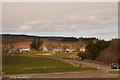
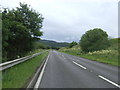
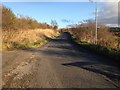
6
A bend in the A96
Heading south east towards Huntly.
Image: © JThomas
Taken: 20 Jul 2014
0.17 miles
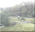
7
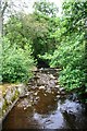
Cairnie Burn
The Cainie burn as it flows on the outskirts of the village of Cairnie.
Image: © Andrew Wood
Taken: 22 Jul 2011
0.20 miles
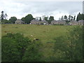
8
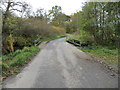
Minor road, Bridge and sometime Ford near Shinsharnie
Looking south-westward.
Image: © Peter Wood
Taken: 23 Oct 2018
0.21 miles
10
Old Bridge of Gilgatherbush
Over the Burn of Cairnie.
Image: © Stanley Howe
Taken: 26 Sep 2011
0.22 miles