IMAGES TAKEN NEAR TO
Cairnie, HUNTLY, AB54 4TJ
Introduction
This page details the photographs taken nearby to AB54 4TJ by members of the Geograph project.
The Geograph project started in 2005 with the aim of publishing, organising and preserving representative images for every square kilometre of Great Britain, Ireland and the Isle of Man.

There are currently over 7.5m images from over14,400 individuals and you can help contribute to the project by visiting https://www.geograph.org.uk
Image Map
Images are licensed for reuse under creativecommons.org/licenses/by-sa/2.0
Notes
- Clicking on the map will re-center to the selected point.
- The higher the marker number, the further away the image location is from the centre of the postcode.
Image Listing (9 Images Found)
Images are licensed for reuse under creativecommons.org/licenses/by-sa/2.0
Image
Details
Distance
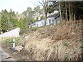
2
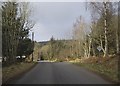
Old military road
A section of the old military road that has been bypassed by the current A96.
Image: © John Allan
Taken: 5 Feb 2007
0.08 miles
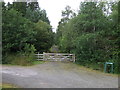
4
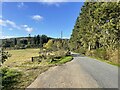
Passing place on narrow country road
Approaching Old Military Road (gate right) and Wood Workers cottages #8/9 (car parked left).
Image: © Stanley Howe
Taken: 19 Mar 2009
0.13 miles
6
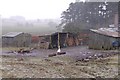
Goose in the woodyard
It had just begun to snow hard. The goose waddles off in search of shelter.
Image: © John Allan
Taken: 5 Feb 2007
0.19 miles
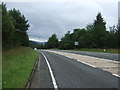
7

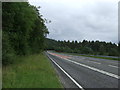
A bend in the A96
Heading south east towards Huntly.
Image: © JThomas
Taken: 20 Jul 2014
0.19 miles