IMAGES TAKEN NEAR TO
Ruthven, HUNTLY, AB54 4SZ
Introduction
This page details the photographs taken nearby to AB54 4SZ by members of the Geograph project.
The Geograph project started in 2005 with the aim of publishing, organising and preserving representative images for every square kilometre of Great Britain, Ireland and the Isle of Man.

There are currently over 7.5m images from over14,400 individuals and you can help contribute to the project by visiting https://www.geograph.org.uk
Image Map
Images are licensed for reuse under creativecommons.org/licenses/by-sa/2.0
Notes
- Clicking on the map will re-center to the selected point.
- The higher the marker number, the further away the image location is from the centre of the postcode.
Image Listing (3 Images Found)
Images are licensed for reuse under creativecommons.org/licenses/by-sa/2.0
Image
Details
Distance
1
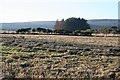
Upper Cuttlehill
This part of the square isn't especially interesting. The farms in the square are all hidden by the lie of the land here.
Image: © Anne Burgess
Taken: 13 Feb 2008
0.20 miles
2
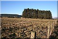
Upper Cuttlehill
Pasture and a shelter belt near Upper Cuttlehill.
Image: © Anne Burgess
Taken: 13 Feb 2008
0.20 miles
3
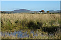
Looking towards Ballochburn
The farm buildings at Ballochburn are just inside the next grid square. On the skyline is Knock Hill.
Image: © Anne Burgess
Taken: 30 Oct 2020
0.23 miles