IMAGES TAKEN NEAR TO
Ruthven, HUNTLY, AB54 4SU
Introduction
This page details the photographs taken nearby to AB54 4SU by members of the Geograph project.
The Geograph project started in 2005 with the aim of publishing, organising and preserving representative images for every square kilometre of Great Britain, Ireland and the Isle of Man.

There are currently over 7.5m images from over14,400 individuals and you can help contribute to the project by visiting https://www.geograph.org.uk
Image Map
Images are licensed for reuse under creativecommons.org/licenses/by-sa/2.0
Notes
- Clicking on the map will re-center to the selected point.
- The higher the marker number, the further away the image location is from the centre of the postcode.
Image Listing (4 Images Found)
Images are licensed for reuse under creativecommons.org/licenses/by-sa/2.0
Image
Details
Distance
2
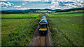
Inverness to Aberdeen Railway Line
The line runs straight here for several miles.
Image: © Anne Burgess
Taken: 15 Feb 2008
0.18 miles
3
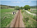
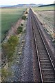
Cairnie Junction railway station (site), Aberdeenshire
Opened in 1897 by the Great North of Scotland Railway on its line from Aberdeen to Keith, this station was the junction for the Moray Coast line. The station closed in 1968. The line was later singled.
View north towards Grange and Keith. The island platform was in the trees in the middle distance. No trace apparently remains.
Image: © Nigel Thompson
Taken: 26 May 2017
0.24 miles
4
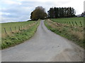
Minor road approaching Netherton
Looking south-eastward.
Image: © Peter Wood
Taken: 23 Oct 2018
0.24 miles