IMAGES TAKEN NEAR TO
Ruthven, HUNTLY, AB54 4ST
Introduction
This page details the photographs taken nearby to AB54 4ST by members of the Geograph project.
The Geograph project started in 2005 with the aim of publishing, organising and preserving representative images for every square kilometre of Great Britain, Ireland and the Isle of Man.

There are currently over 7.5m images from over14,400 individuals and you can help contribute to the project by visiting https://www.geograph.org.uk
Image Map
Images are licensed for reuse under creativecommons.org/licenses/by-sa/2.0
Notes
- Clicking on the map will re-center to the selected point.
- The higher the marker number, the further away the image location is from the centre of the postcode.
Image Listing (3 Images Found)
Images are licensed for reuse under creativecommons.org/licenses/by-sa/2.0
Image
Details
Distance
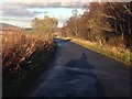
1

Access to Banks farm
From the road between Ruthven and Cairnie.
Image: © Stanley Howe
Taken: 26 Sep 2011
0.10 miles
3
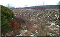
Mystery Landform
I'm not at all sure why this is here. The 1:25,000 map shows what may have been a small house on the left, and a road which would be the continuation of this excavation round to the left. It is being well used now for dumping rubbish, unfortunately.
Image: © Anne Burgess
Taken: 19 Mar 2007
0.16 miles