IMAGES TAKEN NEAR TO
Ruthven, HUNTLY, AB54 4SS
Introduction
This page details the photographs taken nearby to AB54 4SS by members of the Geograph project.
The Geograph project started in 2005 with the aim of publishing, organising and preserving representative images for every square kilometre of Great Britain, Ireland and the Isle of Man.

There are currently over 7.5m images from over14,400 individuals and you can help contribute to the project by visiting https://www.geograph.org.uk
Image Map
Images are licensed for reuse under creativecommons.org/licenses/by-sa/2.0
Notes
- Clicking on the map will re-center to the selected point.
- The higher the marker number, the further away the image location is from the centre of the postcode.
Image Listing (6 Images Found)
Images are licensed for reuse under creativecommons.org/licenses/by-sa/2.0
Image
Details
Distance
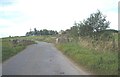
1
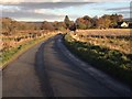
Auchanachie Cottages
On road between Ruthven and Cairnie.
Image: © Stanley Howe
Taken: 26 Sep 2011
0.02 miles
2
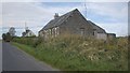
Auchanachie
This looks like a chicken rearing shed. Interestingly, the cottages are named as Auchananachie Cottages [sic] on the 1:25,000 map, while the neighbouring farm is plain Auchanachie. This end of the shed is in square; the far end of the shed, and the cottages, are in the next square. Note the school bus approaching at the right.
Image: © Anne Burgess
Taken: 19 Mar 2007
0.08 miles
3
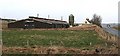
Auchanachie Farm
Auchanachie farm by Ruthven.
Image: © Andrew Wood
Taken: 22 Jul 2011
0.20 miles
4
Clochren Bridge, near Ruthven
Carrying road from Ruthven to Cairnie.
Image: © Stanley Howe
Taken: 26 Sep 2011
0.23 miles
5
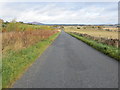
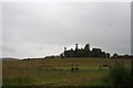
Minor road heading towards Auchananachie
Looking north-eastward
Image: © Peter Wood
Taken: 23 Oct 2018
0.25 miles