IMAGES TAKEN NEAR TO
Cairnie, HUNTLY, AB54 4SP
Introduction
This page details the photographs taken nearby to AB54 4SP by members of the Geograph project.
The Geograph project started in 2005 with the aim of publishing, organising and preserving representative images for every square kilometre of Great Britain, Ireland and the Isle of Man.

There are currently over 7.5m images from over14,400 individuals and you can help contribute to the project by visiting https://www.geograph.org.uk
Image Map
Images are licensed for reuse under creativecommons.org/licenses/by-sa/2.0
Notes
- Clicking on the map will re-center to the selected point.
- The higher the marker number, the further away the image location is from the centre of the postcode.
Image Listing (12 Images Found)
Images are licensed for reuse under creativecommons.org/licenses/by-sa/2.0
Image
Details
Distance
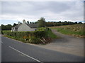
1
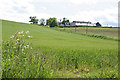
North Tillytarmont
The farm stands on a gentle ridge above the road.
Image: © Anne Burgess
Taken: 18 Jun 2014
0.02 miles
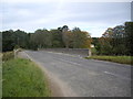
2
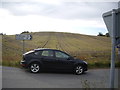
This way to Ruthven and Cairnie
From the B9022 at Bridge of Isla.
Image: © Stanley Howe
Taken: 26 Sep 2011
0.18 miles

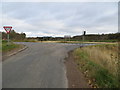
4
Minor road junction with B9022
Near Bridge of Isla.
Image: © Stanley Howe
Taken: 26 Sep 2011
0.19 miles
5
Road from Ruthven joining the B9022 at Bridge of Isla
Looking north-eastward.
Image: © Peter Wood
Taken: 23 Oct 2018
0.19 miles
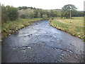
7
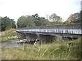
Bridge of Isla
Carrying the B9022 over the River Isla, near its confluence with the River Deveron.
Image: © Stanley Howe
Taken: 26 Sep 2011
0.20 miles
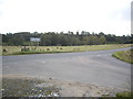
10
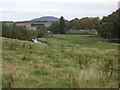
Home Farm, Avochie House
Viewed over the River Deveron from the B9022 near Deveron View.
Image: © Stanley Howe
Taken: 26 Sep 2011
0.21 miles