IMAGES TAKEN NEAR TO
School Road, HUNTLY, AB54 4SG
Introduction
This page details the photographs taken nearby to School Road, AB54 4SG by members of the Geograph project.
The Geograph project started in 2005 with the aim of publishing, organising and preserving representative images for every square kilometre of Great Britain, Ireland and the Isle of Man.

There are currently over 7.5m images from over14,400 individuals and you can help contribute to the project by visiting https://www.geograph.org.uk
Image Map
Images are licensed for reuse under creativecommons.org/licenses/by-sa/2.0
Notes
- Clicking on the map will re-center to the selected point.
- The higher the marker number, the further away the image location is from the centre of the postcode.
Image Listing (26 Images Found)
Images are licensed for reuse under creativecommons.org/licenses/by-sa/2.0
Image
Details
Distance
1
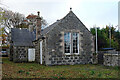
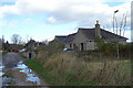
Old Schoolhouse
There's something about the Victorian school houses in this part of the world that makes them instantly recognisable, even when no longer in use as such.
Image: © Anne Burgess
Taken: 30 Oct 2020
0.03 miles
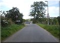
2
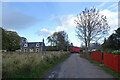
School Road
Looking north along School Road towards the crossroads in Ruthven village. We had watched with considerable interest the considerable efforts of the driver of the large red van, who had not only managed to get it into a narrow gateway on the left, but also got it out again.
Image: © Anne Burgess
Taken: 30 Oct 2020
0.03 miles
3
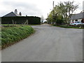
Crossroads in Ruthven
Looking south-eastward towards School Road.
Image: © Peter Wood
Taken: 23 Oct 2018
0.04 miles
4
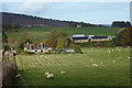
Ruthven
At extreme left is School Road, and to the right is the large steading at Little Daugh Farm. On the higher ground are the farm buildings at Overhall, and an outlying house on the right. The hill on the skyline is Little Balloch.
Image: © Anne Burgess
Taken: 30 Oct 2020
0.04 miles
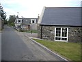
5
School Road
The last two houses in School Road are relatively modern bungalows.
Image: © Anne Burgess
Taken: 30 Oct 2020
0.05 miles
6
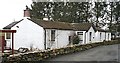
Old Post Office
The little plaque by the window on the central gable says that the cottage was built around 1784. It is now a private house.
Image: © Anne Burgess
Taken: 19 Mar 2007
0.05 miles
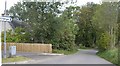
8
Entering Ruthven from the east
On the road from Bridge of Isla.
Image: © Stanley Howe
Taken: 26 Sep 2011
0.06 miles
9
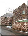
Mill at Ruthven
This building has the look of an old mill about it, and the house across the road is named Mill Cottage. It's in good repair but I don't know what it is currently used for.
Image: © Anne Burgess
Taken: 19 Mar 2007
0.06 miles
10
Ruthven village
Road from Bridge of Isla to Cairnie.
Image: © Stanley Howe
Taken: 26 Sep 2011
0.07 miles