IMAGES TAKEN NEAR TO
Gartly, HUNTLY, AB54 4SD
Introduction
This page details the photographs taken nearby to AB54 4SD by members of the Geograph project.
The Geograph project started in 2005 with the aim of publishing, organising and preserving representative images for every square kilometre of Great Britain, Ireland and the Isle of Man.

There are currently over 7.5m images from over14,400 individuals and you can help contribute to the project by visiting https://www.geograph.org.uk
Image Map
Images are licensed for reuse under creativecommons.org/licenses/by-sa/2.0
Notes
- Clicking on the map will re-center to the selected point.
- The higher the marker number, the further away the image location is from the centre of the postcode.
Image Listing (13 Images Found)
Images are licensed for reuse under creativecommons.org/licenses/by-sa/2.0
Image
Details
Distance
3

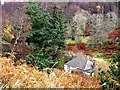
Outbuildings at Glencovey
Glencovey cottage itself can just be seen almost hidden by the grass (bottom left).
Image: © Stanley Howe
Taken: 10 Nov 2009
0.05 miles
4
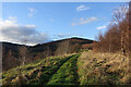
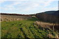
Trails on the Drum
The trails on The Drum climb gently towards the forested Hill of Drumfergue.
Image: © Anne Burgess
Taken: 15 Dec 2020
0.07 miles
5

Road roller heading up Slouch Hill
Cat's Craig hill above and behind the road.
Image: © Stanley Howe
Taken: 10 Nov 2009
0.08 miles
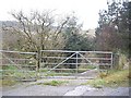
7
Grass Track on The Drum
On the right is the waymarker for the two short trails on The Drum.
Image: © Anne Burgess
Taken: 15 Dec 2020
0.13 miles
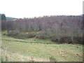
8
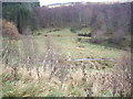
Valley of the Lag Burn
From the Coynachie to Drumfergue road.
Image: © Stanley Howe
Taken: 10 Nov 2009
0.16 miles
9
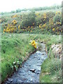
Lag Burn
The Lag burn as it flows towards the forest road and then to its meeting with Priest's Water, a tributary of the River Bogie.
Image: © Andrew Stuart
Taken: 26 May 2007
0.17 miles
10
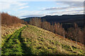
Track on The Drum
Looking back downhill on the waymarked grassy track. The road is in the shade below to the right, so we were glad to have come across the sunny off-road option.
Image: © Anne Burgess
Taken: 15 Dec 2020
0.18 miles