IMAGES TAKEN NEAR TO
Gartly, HUNTLY, AB54 4SB
Introduction
This page details the photographs taken nearby to AB54 4SB by members of the Geograph project.
The Geograph project started in 2005 with the aim of publishing, organising and preserving representative images for every square kilometre of Great Britain, Ireland and the Isle of Man.

There are currently over 7.5m images from over14,400 individuals and you can help contribute to the project by visiting https://www.geograph.org.uk
Image Map
Images are licensed for reuse under creativecommons.org/licenses/by-sa/2.0
Notes
- Clicking on the map will re-center to the selected point.
- The higher the marker number, the further away the image location is from the centre of the postcode.
Image Listing (8 Images Found)
Images are licensed for reuse under creativecommons.org/licenses/by-sa/2.0
Image
Details
Distance
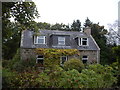
1
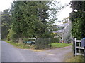
Whitestone of Tillathrowie
The old farm house of Whitestones is hidden among the trees, but a new wooden house has been built nearby.
Image: © Anne Burgess
Taken: 15 Dec 2020
0.02 miles
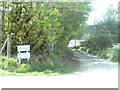
2
Road from Tillathrowie to The Schoolhouse
Image: © Stanley Howe
Taken: 5 Oct 2009
0.14 miles
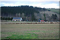
5
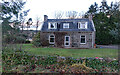
Former School
According to the second edition of the Ordnance Surbey 25-inch map, surveyed in 1899, this house was originally a school.
Image: © Anne Burgess
Taken: 15 Dec 2020
0.15 miles
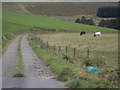
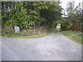
6
Farm Track to Whitestones
One of the many tracks to farms and houses off this road.
Image: © Andrew Stuart
Taken: 26 May 2007
0.17 miles
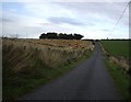
7
Track to Whitestones
For Huntly Herbs. The sign has been replaced since Image
Image: © Stanley Howe
Taken: 5 Oct 2009
0.17 miles