IMAGES TAKEN NEAR TO
HUNTLY, AB54 4SA
Introduction
This page details the photographs taken nearby to AB54 4SA by members of the Geograph project.
The Geograph project started in 2005 with the aim of publishing, organising and preserving representative images for every square kilometre of Great Britain, Ireland and the Isle of Man.

There are currently over 7.5m images from over14,400 individuals and you can help contribute to the project by visiting https://www.geograph.org.uk
Image Map
Images are licensed for reuse under creativecommons.org/licenses/by-sa/2.0
Notes
- Clicking on the map will re-center to the selected point.
- The higher the marker number, the further away the image location is from the centre of the postcode.
Image Listing (14 Images Found)
Images are licensed for reuse under creativecommons.org/licenses/by-sa/2.0
Image
Details
Distance
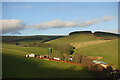
1
Dunscroft
The big farm is Dunscroft. Behind to the left is the Hill of Bogairdy, and to the right is Gallow Hill.
Image: © Anne Burgess
Taken: 15 Dec 2020
0.01 miles
2
Dunscroft
The farm buildings at Dunscroft, and Gallow Hill above.
Image: © Anne Burgess
Taken: 15 Dec 2020
0.02 miles
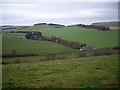
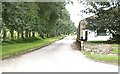
3

Dunscroft
From minor road to Drumfergue.
Image: © Stanley Howe
Taken: 10 Nov 2009
0.04 miles
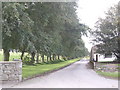
4
A view of Dunscroft
From the Drumfergue road.
Image: © Stanley Howe
Taken: 10 Nov 2009
0.05 miles
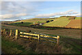
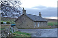
8

Dunscroft cottages
And access road to the farmstead.
Image: © Stanley Howe
Taken: 10 Nov 2009
0.14 miles
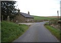
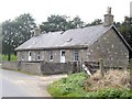
9
Cottages at Dunscroft
When you get close to these cottages you see that they are abandoned and beginning to become derelict.
Image: © Anne Burgess
Taken: 15 Dec 2020
0.14 miles