IMAGES TAKEN NEAR TO
Gartly, HUNTLY, AB54 4RU
Introduction
This page details the photographs taken nearby to AB54 4RU by members of the Geograph project.
The Geograph project started in 2005 with the aim of publishing, organising and preserving representative images for every square kilometre of Great Britain, Ireland and the Isle of Man.

There are currently over 7.5m images from over14,400 individuals and you can help contribute to the project by visiting https://www.geograph.org.uk
Image Map
Images are licensed for reuse under creativecommons.org/licenses/by-sa/2.0
Notes
- Clicking on the map will re-center to the selected point.
- The higher the marker number, the further away the image location is from the centre of the postcode.
Image Listing (31 Images Found)
Images are licensed for reuse under creativecommons.org/licenses/by-sa/2.0
Image
Details
Distance
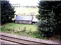
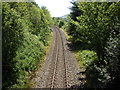
2
Upline at Millhill
Towards Gartly and Aberdeen.
Image: © Stanley Howe
Taken: 11 Apr 2011
0.03 miles
3
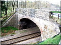
Bridge over the railway at Millhill
Looking right towards Huntly.
Image: © Stanley Howe
Taken: 11 Apr 2011
0.05 miles
4
Riverside access to Millhill Croft
River Bogie to the right.
Image: © Stanley Howe
Taken: 29 May 2009
0.05 miles
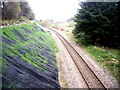
5
Railway line from Huntly to Insch
Near Bridgend.
Image: © Stanley Howe
Taken: 29 May 2009
0.05 miles
7
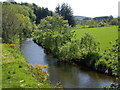
Downstream River Bogie
From the road bridge near Bridgend.
Image: © Stanley Howe
Taken: 29 May 2009
0.05 miles
8
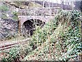
Bridge over the railway at Millhill
Right towards Gartly and Aberdeen.
Image: © Stanley Howe
Taken: 11 Apr 2011
0.05 miles
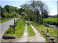
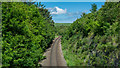
10
Road to Bridge of Bogie
From the railway bridge near Bridgend.
Image: © Stanley Howe
Taken: 29 May 2009
0.07 miles