IMAGES TAKEN NEAR TO
Gartly, HUNTLY, AB54 4RQ
Introduction
This page details the photographs taken nearby to AB54 4RQ by members of the Geograph project.
The Geograph project started in 2005 with the aim of publishing, organising and preserving representative images for every square kilometre of Great Britain, Ireland and the Isle of Man.

There are currently over 7.5m images from over14,400 individuals and you can help contribute to the project by visiting https://www.geograph.org.uk
Image Map
Images are licensed for reuse under creativecommons.org/licenses/by-sa/2.0
Notes
- Clicking on the map will re-center to the selected point.
- The higher the marker number, the further away the image location is from the centre of the postcode.
Image Listing (8 Images Found)
Images are licensed for reuse under creativecommons.org/licenses/by-sa/2.0
Image
Details
Distance
1
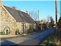
The Smiddy
The former blacksmith's in Backburn is now a residentiual property.
Image: © James Allan
Taken: 1 Dec 2006
0.03 miles
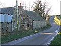
2
The Smithy
The Smithy and other buildings at Backburn farm, bisected by the Old Military Road.
Image: © Andrew Stuart
Taken: 5 Jun 2007
0.04 miles
3
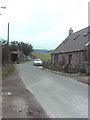
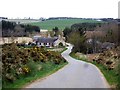
Backburn
The minor road passes close to the houses at Backburn.
Image: © Anne Burgess
Taken: 1 Mar 2022
0.04 miles
5
Abandoned cottage
A derelict cottage in Backburn.
Image: © James Allan
Taken: 1 Dec 2006
0.11 miles
6
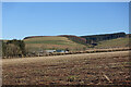
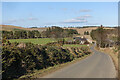
Field near West Corncatterach
The farm buildings at West Corncatterach are actually in the next grid square. To their right is the course of the Glen Burn.
Image: © Anne Burgess
Taken: 1 Mar 2022
0.13 miles
7
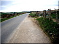
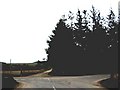
A road summit
Between Backhill and Gartly.
Image: © Stanley Howe
Taken: 11 Apr 2011
0.20 miles