IMAGES TAKEN NEAR TO
HUNTLY, AB54 4RL
Introduction
This page details the photographs taken nearby to AB54 4RL by members of the Geograph project.
The Geograph project started in 2005 with the aim of publishing, organising and preserving representative images for every square kilometre of Great Britain, Ireland and the Isle of Man.

There are currently over 7.5m images from over14,400 individuals and you can help contribute to the project by visiting https://www.geograph.org.uk
Image Map
Images are licensed for reuse under creativecommons.org/licenses/by-sa/2.0
Notes
- Clicking on the map will re-center to the selected point.
- The higher the marker number, the further away the image location is from the centre of the postcode.
Image Listing (6 Images Found)
Images are licensed for reuse under creativecommons.org/licenses/by-sa/2.0
Image
Details
Distance
1
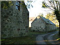
Bothwellseat
Abandoned farm buildings at Bothwellseat.
Image: © James Allan
Taken: 1 Dec 2006
0.07 miles
2
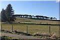
Fields at Bothwellseat
Low winter light catches a few bales left in the far field.
Image: © Anne Burgess
Taken: 1 Mar 2022
0.14 miles
3
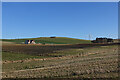
Den Burn
The Den burn flows down the far side of this field. The house above it, Braeview, is just in the next square, and to the right is the wind farm at Newtongarry.
Image: © Anne Burgess
Taken: 1 Mar 2022
0.22 miles
4
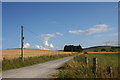
The Gartly Road
The road to Gartly by Bothwellseat.
Image: © Andrew Wood
Taken: 24 Aug 2011
0.23 miles
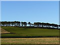
5
Cot Hill
Bothwellseat plantation at the summit of Cot Hill.
Image: © Andrew Wood
Taken: 24 Aug 2011
0.24 miles
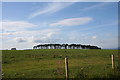
6
Trees on a ridge
Bothwellseat Plantation on Cot Hill.
Image: © James Allan
Taken: 1 Dec 2006
0.25 miles