IMAGES TAKEN NEAR TO
HUNTLY, AB54 4RB
Introduction
This page details the photographs taken nearby to AB54 4RB by members of the Geograph project.
The Geograph project started in 2005 with the aim of publishing, organising and preserving representative images for every square kilometre of Great Britain, Ireland and the Isle of Man.

There are currently over 7.5m images from over14,400 individuals and you can help contribute to the project by visiting https://www.geograph.org.uk
Image Map
Images are licensed for reuse under creativecommons.org/licenses/by-sa/2.0
Notes
- Clicking on the map will re-center to the selected point.
- The higher the marker number, the further away the image location is from the centre of the postcode.
Image Listing (1 Images Found)
Images are licensed for reuse under creativecommons.org/licenses/by-sa/2.0
Image
Details
Distance
1
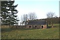
Wester Newbigging
This is not the sort of place I would expect to meet anyone else on a cold November day. To my surprise, there were two young ladies surveying and photographing this abandoned cottage, which is shortly to be advertised for sale. There are currently two other cottages for sale, in a similar state, though a little easier of access, on the road leading up to the field in which Wester Newbigging stands.
Image: © Anne Burgess
Taken: 27 Nov 2008
0.02 miles