IMAGES TAKEN NEAR TO
Kennethmont, HUNTLY, AB54 4QL
Introduction
This page details the photographs taken nearby to AB54 4QL by members of the Geograph project.
The Geograph project started in 2005 with the aim of publishing, organising and preserving representative images for every square kilometre of Great Britain, Ireland and the Isle of Man.

There are currently over 7.5m images from over14,400 individuals and you can help contribute to the project by visiting https://www.geograph.org.uk
Image Map
Images are licensed for reuse under creativecommons.org/licenses/by-sa/2.0
Notes
- Clicking on the map will re-center to the selected point.
- The higher the marker number, the further away the image location is from the centre of the postcode.
Image Listing (6 Images Found)
Images are licensed for reuse under creativecommons.org/licenses/by-sa/2.0
Image
Details
Distance
1
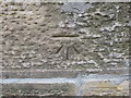
Ordnance Survey Cut Mark
This can be found on the parapet of a bridge over Water of Bogie at Smithston. The benchmark height is recorded as being 160.178 metres above sea level.
For more detail see : https://www.bench-marks.org.uk/bm101724
Image: © Peter Wood
Taken: 22 Oct 2018
0.04 miles
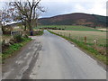
2
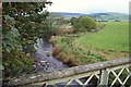
Bridge over the Water of Bogie near Smithston
Image: © Des Colhoun
Taken: 25 Oct 2006
0.04 miles
3
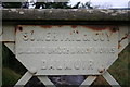
Bogie bridge at Smithston and the builders name with pride.
A hint of the halcyon days of British engineering when manufacturers were proud to be associated with their products.
Image: © Des Colhoun
Taken: 25 Oct 2006
0.04 miles
4
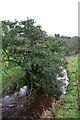
The Alder populated banks of the Bogie.
Image: © Des Colhoun
Taken: 25 Oct 2006
0.06 miles
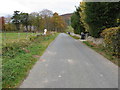
6
Road at the entrance to Mains of Craighall
Looking westward.
Image: © Peter Wood
Taken: 22 Oct 2018
0.21 miles