IMAGES TAKEN NEAR TO
Gartly, HUNTLY, AB54 4QD
Introduction
This page details the photographs taken nearby to AB54 4QD by members of the Geograph project.
The Geograph project started in 2005 with the aim of publishing, organising and preserving representative images for every square kilometre of Great Britain, Ireland and the Isle of Man.

There are currently over 7.5m images from over14,400 individuals and you can help contribute to the project by visiting https://www.geograph.org.uk
Image Map
Images are licensed for reuse under creativecommons.org/licenses/by-sa/2.0
Notes
- Clicking on the map will re-center to the selected point.
- The higher the marker number, the further away the image location is from the centre of the postcode.
Image Listing (10 Images Found)
Images are licensed for reuse under creativecommons.org/licenses/by-sa/2.0
Image
Details
Distance
1
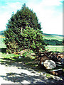
Holly tree
Sawn timber in the foreground and a holly tree at Kirkney Farm.
Image: © Andrew Stuart
Taken: 6 May 2007
0.07 miles
2

Old Reaper
From days before the combine & forage harvester.
Image: © Andrew Stuart
Taken: 6 May 2007
0.07 miles
3
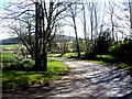
Bend in road at Kirkney
Close to the end of the public road there.
Image: © Stanley Howe
Taken: 12 Apr 2011
0.07 miles
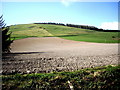
5
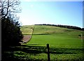
A neatly quartered hillside above Berwyn
From the Whitelumbs to Kirkney road.
Image: © Stanley Howe
Taken: 12 Apr 2011
0.19 miles
7
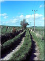
The Road to nowhere
Actually it does, it goes from Kirkney to Kirkney mains
Image: © Andrew Stuart
Taken: 6 May 2007
0.20 miles
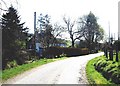
8
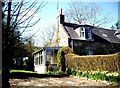
Berwyn cottage
Between Whitelumbs and Kirkney.
Image: © Stanley Howe
Taken: 12 Apr 2011
0.20 miles
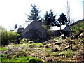
9
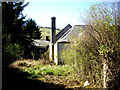
The abandoned croft? Another view.
Can anyone please supply a name and history for this building?
Image: © Stanley Howe
Taken: 12 Apr 2011
0.20 miles
10
An abandoned croft?
Between Berwyn and Whitelumbs.
Image: © Stanley Howe
Taken: 12 Apr 2011
0.21 miles