IMAGES TAKEN NEAR TO
Clatt, HUNTLY, AB54 4PJ
Introduction
This page details the photographs taken nearby to AB54 4PJ by members of the Geograph project.
The Geograph project started in 2005 with the aim of publishing, organising and preserving representative images for every square kilometre of Great Britain, Ireland and the Isle of Man.

There are currently over 7.5m images from over14,400 individuals and you can help contribute to the project by visiting https://www.geograph.org.uk
Image Map
Images are licensed for reuse under creativecommons.org/licenses/by-sa/2.0
Notes
- Clicking on the map will re-center to the selected point.
- The higher the marker number, the further away the image location is from the centre of the postcode.
Image Listing (16 Images Found)
Images are licensed for reuse under creativecommons.org/licenses/by-sa/2.0
Image
Details
Distance
1
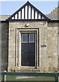
Front door and porch
Ford of Clatt cottage.
Image: © Stanley Howe
Taken: 2 Apr 2009
0.01 miles
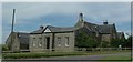
3
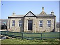
Cottage at Ford of Clatt
With a fancy gabled porch, and rainwater barrels in the garden.
Image: © Stanley Howe
Taken: 2 Apr 2009
0.01 miles
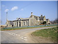
4
Road junction by Ford
Approached from Suie hill.
Image: © Stanley Howe
Taken: 17 Jul 2014
0.02 miles
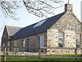
5
Redevelopment at Ford
Converted steading.
Image: © Stanley Howe
Taken: 2 Apr 2009
0.02 miles
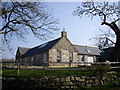
6
Ford steading
Renovated as a dwelling, with solar panels on the roof.
Image: © Stanley Howe
Taken: 2 Apr 2009
0.04 miles
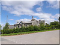
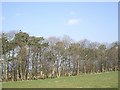
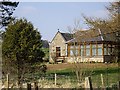
7
Ford farm
At foot of Suie Hill near Clatt
Image: © Stanley Howe
Taken: 13 Jul 2006
0.04 miles
8
A rookery at Ford
With early signs of breeding activity.
Image: © Stanley Howe
Taken: 2 Apr 2009
0.07 miles
10
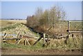
A drain by Viewfield
Flowing downstream towards the Gadie Burn.
Image: © Stanley Howe
Taken: 2 Apr 2009
0.10 miles