IMAGES TAKEN NEAR TO
Clatt, HUNTLY, AB54 4PG
Introduction
This page details the photographs taken nearby to AB54 4PG by members of the Geograph project.
The Geograph project started in 2005 with the aim of publishing, organising and preserving representative images for every square kilometre of Great Britain, Ireland and the Isle of Man.

There are currently over 7.5m images from over14,400 individuals and you can help contribute to the project by visiting https://www.geograph.org.uk
Image Map
Images are licensed for reuse under creativecommons.org/licenses/by-sa/2.0
Notes
- Clicking on the map will re-center to the selected point.
- The higher the marker number, the further away the image location is from the centre of the postcode.
Image Listing (4 Images Found)
Images are licensed for reuse under creativecommons.org/licenses/by-sa/2.0
Image
Details
Distance
1
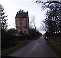
Towerlodge; access to Knockespock House
Off Premnay to Ford road, near Little Newton.
Image: © Stanley Howe
Taken: 6 Dec 2014
0.01 miles
2
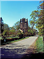
Knockespock Lodge
Knockespock Lodge is a tower house on the side of the Clatt - Leslie road.
Image: © Andrew Stuart
Taken: 28 Apr 2007
0.03 miles
3
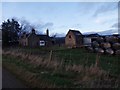
Farmstead at Little Newton
By road between Leslie and Ford.
Image: © Stanley Howe
Taken: 6 Dec 2014
0.16 miles
4
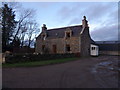
Little Newton
A farmhouse by the Leslie to Clatt road.
Image: © Stanley Howe
Taken: 6 Dec 2014
0.17 miles