IMAGES TAKEN NEAR TO
Kennethmont, HUNTLY, AB54 4PF
Introduction
This page details the photographs taken nearby to AB54 4PF by members of the Geograph project.
The Geograph project started in 2005 with the aim of publishing, organising and preserving representative images for every square kilometre of Great Britain, Ireland and the Isle of Man.

There are currently over 7.5m images from over14,400 individuals and you can help contribute to the project by visiting https://www.geograph.org.uk
Image Map
Images are licensed for reuse under creativecommons.org/licenses/by-sa/2.0
Notes
- Clicking on the map will re-center to the selected point.
- The higher the marker number, the further away the image location is from the centre of the postcode.
Image Listing (5 Images Found)
Images are licensed for reuse under creativecommons.org/licenses/by-sa/2.0
Image
Details
Distance
1
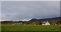
Kennethmont
Tap o' Noth in the background.
Image: © Richard Webb
Taken: 14 Apr 2015
0.14 miles
2
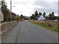
Suie Road from Kennethmont towards Clatt
Looking south-eastward.
Image: © Peter Wood
Taken: 22 Oct 2018
0.16 miles
4
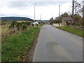
Road (B9002) leaving Kennethmont
Looking north-westward.
Image: © Peter Wood
Taken: 22 Oct 2018
0.22 miles
5
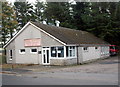
Village Chinese restaurant
A somewhat remote Aberdeenshire village is an unusual location for a Chinese take-away.
Image: © Bill Harrison
Taken: 7 Oct 2017
0.24 miles