IMAGES TAKEN NEAR TO
Clatt, HUNTLY, AB54 4LY
Introduction
This page details the photographs taken nearby to AB54 4LY by members of the Geograph project.
The Geograph project started in 2005 with the aim of publishing, organising and preserving representative images for every square kilometre of Great Britain, Ireland and the Isle of Man.

There are currently over 7.5m images from over14,400 individuals and you can help contribute to the project by visiting https://www.geograph.org.uk
Image Map
Images are licensed for reuse under creativecommons.org/licenses/by-sa/2.0
Notes
- Clicking on the map will re-center to the selected point.
- The higher the marker number, the further away the image location is from the centre of the postcode.
Image Listing (10 Images Found)
Images are licensed for reuse under creativecommons.org/licenses/by-sa/2.0
Image
Details
Distance
3
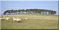
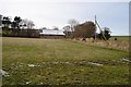
A break for 'allowances'
Sheep taking a break from grazing to browse, near Auchmenzie.
Image: © Stanley Howe
Taken: 2 Apr 2009
0.16 miles
4
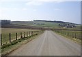
Road to Rhynie
With Meadowbank right ahead, Stonedike left ahead, and Cushnie far left.
Image: © Stanley Howe
Taken: 2 Apr 2009
0.17 miles
5
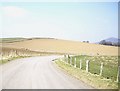
A bend in Clatt to Rhynie road
With Tap O'Noth visible far right.
Image: © Stanley Howe
Taken: 2 Apr 2009
0.18 miles
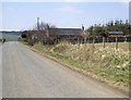
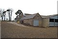
7
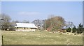
West Auchmenzie Farm
The farm lies about 130 m the north of the road from Clatt to Rhynie
Image: © Morley Sewell
Taken: 27 Jan 2009
0.21 miles
8
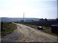
Track to Cushnie
Off Clatt to Rhynie road.
Image: © Stanley Howe
Taken: 2 Apr 2009
0.21 miles
9
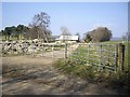
Access to West Auchmenzie
From Clatt to Rhynie road.
Image: © Stanley Howe
Taken: 2 Apr 2009
0.23 miles
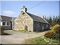
10
Meadowbank Farm
The farm lies in the relatively flat land to north of the Correen Hills and to the west of Strathbogie
Image: © Morley Sewell
Taken: 27 Jan 2009
0.24 miles