IMAGES TAKEN NEAR TO
Rhynie, HUNTLY, AB54 4LS
Introduction
This page details the photographs taken nearby to AB54 4LS by members of the Geograph project.
The Geograph project started in 2005 with the aim of publishing, organising and preserving representative images for every square kilometre of Great Britain, Ireland and the Isle of Man.

There are currently over 7.5m images from over14,400 individuals and you can help contribute to the project by visiting https://www.geograph.org.uk
Image Map
Images are licensed for reuse under creativecommons.org/licenses/by-sa/2.0
Notes
- Clicking on the map will re-center to the selected point.
- The higher the marker number, the further away the image location is from the centre of the postcode.
Image Listing (30 Images Found)
Images are licensed for reuse under creativecommons.org/licenses/by-sa/2.0
Image
Details
Distance
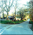
4
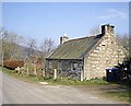
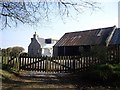
Cottage at Cottown
A traditional stone cottage with modern windows.
Image: © Anne Burgess
Taken: 5 Nov 2020
0.05 miles
6
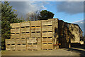
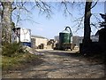
Tattie Boxes at Cottown
Traditional wooden boxes stored ready for the imminent tattie crop.
Image: © Anne Burgess
Taken: 5 Nov 2020
0.05 miles
7
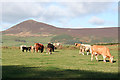
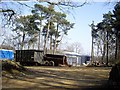
Cattle at Cottown
Having evidently decided that I was less interesting than the grass, these cows and calves were getting on with eating, oblivious to the splendid view towards Tap o' Noth in NJ4829.
Image: © Anne Burgess
Taken: 22 Oct 2015
0.06 miles
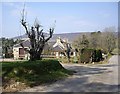
10
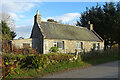
To Clatt or Clatt
The junction at Cottown, both roads leading to Clatt; the road to the right comes out in the centre of Clatt and the road to the left comes out a few hundred yards outside the village.
Image: © Andrew Stuart
Taken: 27 Apr 2007
0.07 miles