IMAGES TAKEN NEAR TO
Rhynie, HUNTLY, AB54 4LR
Introduction
This page details the photographs taken nearby to AB54 4LR by members of the Geograph project.
The Geograph project started in 2005 with the aim of publishing, organising and preserving representative images for every square kilometre of Great Britain, Ireland and the Isle of Man.

There are currently over 7.5m images from over14,400 individuals and you can help contribute to the project by visiting https://www.geograph.org.uk
Image Map
Images are licensed for reuse under creativecommons.org/licenses/by-sa/2.0
Notes
- Clicking on the map will re-center to the selected point.
- The higher the marker number, the further away the image location is from the centre of the postcode.
Image Listing (10 Images Found)
Images are licensed for reuse under creativecommons.org/licenses/by-sa/2.0
Image
Details
Distance
1
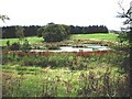
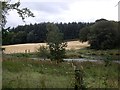
Cuttieburn through the trees
Taken from the fork in the farm track.
Image: © Andrew Stuart
Taken: 14 May 2007
0.11 miles
2
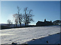
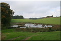
Farm Cottage near Cuttieburn snowbound
The reason why the Cabrach road is often closed in winter
Image: © Alan Reid
Taken: Unknown
0.12 miles
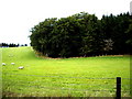
3
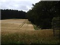
Ripening cereal crop
Near Craig Castle.
Image: © Stanley Howe
Taken: 29 Aug 2011
0.14 miles
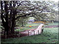
4

Craik junction
On B9002 near Craig Castle.
Image: © Stanley Howe
Taken: 22 Oct 2007
0.19 miles

8

West entrance to Craig Castle
From B9002.
Image: © Stanley Howe
Taken: 22 Oct 2007
0.22 miles