IMAGES TAKEN NEAR TO
Rhynie, HUNTLY, AB54 4LJ
Introduction
This page details the photographs taken nearby to AB54 4LJ by members of the Geograph project.
The Geograph project started in 2005 with the aim of publishing, organising and preserving representative images for every square kilometre of Great Britain, Ireland and the Isle of Man.

There are currently over 7.5m images from over14,400 individuals and you can help contribute to the project by visiting https://www.geograph.org.uk
Image Map
Images are licensed for reuse under creativecommons.org/licenses/by-sa/2.0
Notes
- Clicking on the map will re-center to the selected point.
- The higher the marker number, the further away the image location is from the centre of the postcode.
Image Listing (9 Images Found)
Images are licensed for reuse under creativecommons.org/licenses/by-sa/2.0
Image
Details
Distance
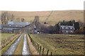
1
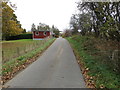
Minor road at Wethaugh
Looking eastward.
Image: © Peter Wood
Taken: 22 Oct 2018
0.02 miles
2
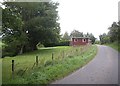
'Little Tring' chalet
By the minor road between Rhynie and Craig Castle, near the Ord Burn crossing.
Image: © Stanley Howe
Taken: 29 Aug 2011
0.03 miles
4
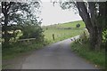
Ord Burn crossing
Near Wardhaugh on back road from Rhynie to Craig Castle.
Image: © Stanley Howe
Taken: 29 Aug 2011
0.06 miles
5
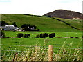
View towards Ord Hill
Upper Ord farm in foreground (NJ4827). Tap O'Noth in distance.
Image: © Stanley Howe
Taken: 20 Sep 2007
0.14 miles
6
Access track to Ord farm
With the beautiful purple heather-clad Ord Hill in the background
Image: © Stanley Howe
Taken: 29 Aug 2011
0.16 miles
7
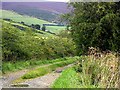
Valley of the Ord Burn
Below the track junction to Templand, on the Rhynie to Craig Castle road. Cairn More wind turbines in the background.
Image: © Stanley Howe
Taken: 29 Aug 2011
0.17 miles
8
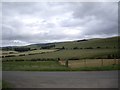
Upper Ord Farm
Seen from the minor road between Rhynie and Craig Castle; with Tap O'Noth rear right.
Image: © Stanley Howe
Taken: 29 Aug 2011
0.22 miles
9
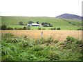
Upper Ord farm
The farm lies on the northwest side of Strathbogie and to the west of Rhynie. Ord Hill is in the background.
Image: © Morley Sewell
Taken: 27 Jan 2009
0.22 miles