IMAGES TAKEN NEAR TO
Lumsden, HUNTLY, AB54 4JX
Introduction
This page details the photographs taken nearby to AB54 4JX by members of the Geograph project.
The Geograph project started in 2005 with the aim of publishing, organising and preserving representative images for every square kilometre of Great Britain, Ireland and the Isle of Man.

There are currently over 7.5m images from over14,400 individuals and you can help contribute to the project by visiting https://www.geograph.org.uk
Image Map
Images are licensed for reuse under creativecommons.org/licenses/by-sa/2.0
Notes
- Clicking on the map will re-center to the selected point.
- The higher the marker number, the further away the image location is from the centre of the postcode.
Image Listing (11 Images Found)
Images are licensed for reuse under creativecommons.org/licenses/by-sa/2.0
Image
Details
Distance
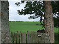
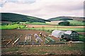
1
Entrance to Lochans
From the Honeybarrel road.
Image: © Stanley Howe
Taken: 15 Jun 2007
0.01 miles
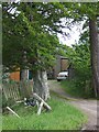
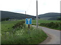
2
Access to Lochans
From Birkenbower to Honeybarrel road.
Image: © Stanley Howe
Taken: 25 Aug 2010
0.02 miles
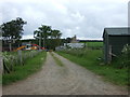
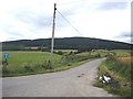
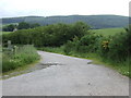
4
Road to Blackbaulk and Wester Clova
From Lochans.
Image: © Stanley Howe
Taken: 15 Jun 2007
0.09 miles
5
Side road to Wester Clova
From Lochans.
Image: © Stanley Howe
Taken: 25 Aug 2010
0.12 miles
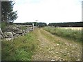
6
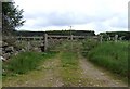
Track to Drumnahive Wood
From Honeybarrel road near Lochans.
Image: © Stanley Howe
Taken: 15 Jun 2007
0.13 miles
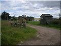
7
Track to Drumnahive Wood
Who left the gate open, and the pheasant in? See Image] .
Image: © Stanley Howe
Taken: 25 Aug 2010
0.17 miles
8
Road to Broadley
From Honeybarrel road at Mosshead.
Image: © Stanley Howe
Taken: 15 Jun 2007
0.18 miles