IMAGES TAKEN NEAR TO
Lumsden, HUNTLY, AB54 4JW
Introduction
This page details the photographs taken nearby to AB54 4JW by members of the Geograph project.
The Geograph project started in 2005 with the aim of publishing, organising and preserving representative images for every square kilometre of Great Britain, Ireland and the Isle of Man.

There are currently over 7.5m images from over14,400 individuals and you can help contribute to the project by visiting https://www.geograph.org.uk
Image Map
Images are licensed for reuse under creativecommons.org/licenses/by-sa/2.0
Notes
- Clicking on the map will re-center to the selected point.
- The higher the marker number, the further away the image location is from the centre of the postcode.
Image Listing (20 Images Found)
Images are licensed for reuse under creativecommons.org/licenses/by-sa/2.0
Image
Details
Distance
2
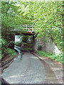
Approach to a low bridge
Nine feet, nine inches! How many years since Britain went metric?
Image: © Stanley Howe
Taken: 15 Jun 2007
0.03 miles
3
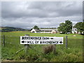
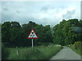
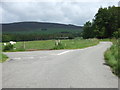
Road sign at Birkenbower junction
Birkenbower farm in the background.
Image: © Stanley Howe
Taken: 25 Aug 2010
0.04 miles
4
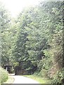
Approach to Birkembower road bridge
Carrying the driveway to Clova from the A97.
Image: © Stanley Howe
Taken: 25 Aug 2010
0.04 miles
6
Bridge
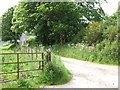
Original main driveway to Clova passed over this bridge enroute to "The Big House."
Image: © Andrew Stuart
Taken: 20 May 2007
0.05 miles

9
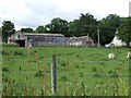
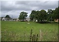
View of Birkenbower
From the road by the Mossat Burn.
Image: © Stanley Howe
Taken: 15 Jun 2007
0.06 miles
10
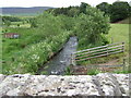
Downstream Mossat Burn
From bridge at Mill of Birkenbower.
Image: © Stanley Howe
Taken: 15 Jun 2007
0.08 miles