IMAGES TAKEN NEAR TO
Essie Crescent, HUNTLY, AB54 4GS
Introduction
This page details the photographs taken nearby to Essie Crescent, AB54 4GS by members of the Geograph project.
The Geograph project started in 2005 with the aim of publishing, organising and preserving representative images for every square kilometre of Great Britain, Ireland and the Isle of Man.

There are currently over 7.5m images from over14,400 individuals and you can help contribute to the project by visiting https://www.geograph.org.uk
Image Map
Images are licensed for reuse under creativecommons.org/licenses/by-sa/2.0
Notes
- Clicking on the map will re-center to the selected point.
- The higher the marker number, the further away the image location is from the centre of the postcode.
Image Listing (67 Images Found)
Images are licensed for reuse under creativecommons.org/licenses/by-sa/2.0
Image
Details
Distance
1
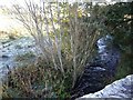
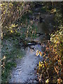
Downstream Ord Burn
From Essie road bridge, Rhynie.
Image: © Stanley Howe
Taken: 3 Nov 2008
0.08 miles
2
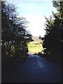
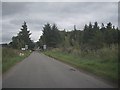
Essie road out of Rhynie
Tap O'Noth ahead.
Image: © Stanley Howe
Taken: 3 Nov 2008
0.09 miles
3
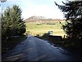
Bridge over Ord Burn
On road from Rhynie to Essie. Tap O'Noth ahead.
Image: © Stanley Howe
Taken: 3 Nov 2008
0.10 miles
5
Rhynie Village Green and Tap O'Noth
Image: © Richard Slessor
Taken: 22 Aug 2004
0.11 miles
6
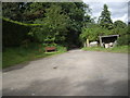
Rhynie cemetery carpark
With the 'Symbol Stones' in the shed (back right).
Image: © Stanley Howe
Taken: 28 Aug 2013
0.11 miles
7
Approach to Bridge of Easaiche, Rhynie
On A941 from The Cabrach.
Image: © Stanley Howe
Taken: 29 Aug 2011
0.12 miles
8
Upstream Ord Burn
From the bridge on Essie Road.
Image: © Stanley Howe
Taken: 3 Nov 2007
0.13 miles
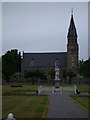
9
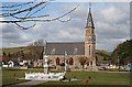
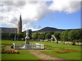
Rhynie Kirk
The kirk and war memorial in the village of Rhynie.
Image: © Anne Burgess
Taken: 6 Apr 2007
0.15 miles
10
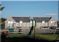
Rhynie primary school
School roll (2016-17): 48 children in three composite classes.
Image: © Bill Harrison
Taken: 23 Sep 2017
0.15 miles