IMAGES TAKEN NEAR TO
South Road, HUNTLY, AB54 4GA
Introduction
This page details the photographs taken nearby to South Road, AB54 4GA by members of the Geograph project.
The Geograph project started in 2005 with the aim of publishing, organising and preserving representative images for every square kilometre of Great Britain, Ireland and the Isle of Man.

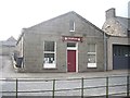
There are currently over 7.5m images from over14,400 individuals and you can help contribute to the project by visiting https://www.geograph.org.uk
Image Map
Images are licensed for reuse under creativecommons.org/licenses/by-sa/2.0
Notes
- Clicking on the map will re-center to the selected point.
- The higher the marker number, the further away the image location is from the centre of the postcode.
Image Listing (96 Images Found)
Images are licensed for reuse under creativecommons.org/licenses/by-sa/2.0
Image
Details
Distance
1
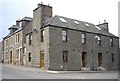
SE corner of The Square, Rhynie
Leading right to The Muirs.
Image: © Stanley Howe
Taken: 21 Mar 2009
0.02 miles
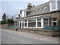
2
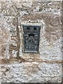
Flush Bracket OSBM G928: Rhynie, #6 South Road
Flush Bracket OSBM G928: Rhynie, Number 6 South Road
Image: © thejackrustles
Taken: 21 Sep 2018
0.02 miles
3
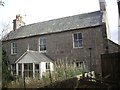
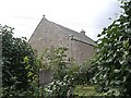
Access path from A97 to the former Free Church in Rhynie
The short path on the right, past a large house with porch, leads to the hidden and now disused church building behind. Was this perhaps the Minister's house? It has a good view of The Square in Rhynie.
Image: © Stanley Howe
Taken: 28 Aug 2013
0.02 miles
4
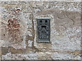
Ordnance Survey Flush Bracket G928
This can be found on the roadside wall of a house in South Street, Rhynie. The benchmark height is recorded as being 185.08 metres above sea level.
For more detail see : https://www.bench-marks.org.uk/bm359
Image: © Peter Wood
Taken: 22 Oct 2018
0.02 miles
5
Rhynie Church Hall
As the name indicates, its address is #14 The Square, Rhynie.
Image: © Stanley Howe
Taken: 28 Aug 2013
0.04 miles
6
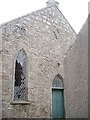
Former Free Church, Rhynie
Disused, and with broken windows. The stone plaque at the gable head bears a date of 1851. See http://www.scottishchurches.org.uk/sites/site/id/4123/name/Rhynie+Former+Free+Church+Rhynie+Grampian for more detail.
Image: © Stanley Howe
Taken: 28 Aug 2013
0.04 miles
7
Former Free Church, Rhynie
Viewed from a back lane, and with its east end windows cemented up. See http://www.scottishchurches.org.uk/sites/site/id/4123/name/Rhynie+Former+Free+Church+Rhynie+Grampian
Image: © Stanley Howe
Taken: 28 Aug 2013
0.05 miles
8
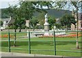
Rhynie & Kearn War Memorial
See http://www.kinnethmont.co.uk/rhynie/ The carved statue of the soldier in granite was the work of Robert Warrack Morrison (1890-1945), later manager of Morren's, Holland Street, Aberdeen. See http://www.leopardmag.co.uk/feats/42/robert-morrison-king-of-the-granite-carvers
Image: © Stanley Howe
Taken: 13 Jul 2006
0.05 miles
9
Rowanlea; last house in Rhynie
Exiting via A97 south. Opposite the access road to the cemetery, with its symbol stane.
Image: © Stanley Howe
Taken: 21 Mar 2009
0.05 miles
10
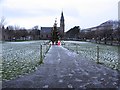
The Square, Rhynie
Mid afternoon and it was almost dark, this is a long exposure. The Christmas tree is in front of the war memorial.
Image: © Richard Webb
Taken: 20 Dec 2011
0.05 miles