IMAGES TAKEN NEAR TO
Moss Road, HUNTLY, AB54 4EG
Introduction
This page details the photographs taken nearby to Moss Road, AB54 4EG by members of the Geograph project.
The Geograph project started in 2005 with the aim of publishing, organising and preserving representative images for every square kilometre of Great Britain, Ireland and the Isle of Man.

There are currently over 7.5m images from over14,400 individuals and you can help contribute to the project by visiting https://www.geograph.org.uk
Image Map
Images are licensed for reuse under creativecommons.org/licenses/by-sa/2.0
Notes
- Clicking on the map will re-center to the selected point.
- The higher the marker number, the further away the image location is from the centre of the postcode.
Image Listing (93 Images Found)
Images are licensed for reuse under creativecommons.org/licenses/by-sa/2.0
Image
Details
Distance
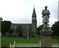
1
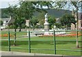
Rhynie & Kearn War Memorial
See http://www.kinnethmont.co.uk/rhynie/ The carved statue of the soldier in granite was the work of Robert Warrack Morrison (1890-1945), later manager of Morren's, Holland Street, Aberdeen. See http://www.leopardmag.co.uk/feats/42/robert-morrison-king-of-the-granite-carvers
Image: © Stanley Howe
Taken: 13 Jul 2006
0.03 miles
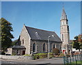
2
Rhynie Parish Church and carpark
The Square, Rhynie.
Image: © Stanley Howe
Taken: 28 Aug 2013
0.03 miles
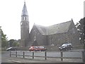
3
Rhynie church clock tower
This spired octagonal clock tower was added in 1889, adjacent to the church of 1823. It was the gift of a man born locally, who had become a successful tradesman in Melbourne (Australia).
Image: © Stanley Howe
Taken: 13 Jul 2006
0.04 miles
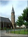
4
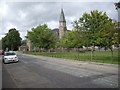
Rhynie Kirk and flagpole
Viewed from by the war memorial.
Image: © Stanley Howe
Taken: 28 Aug 2013
0.04 miles
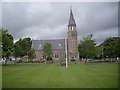
5
Rhynie - Parish Church
The church stands at one end of The Square which has the War Memorial as its focal point http://www.rhynie.mysite.com/index.html.
Image: © Colin Smith
Taken: 6 Jul 2024
0.04 miles
6
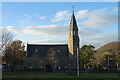
Rhynie Parish Kirk
The original building, dating from 1823, was a simple 'preaching-box'. It was doubled in size in 1838, and the spire was added in 1889. inside is a font reputed to be 12th century.
Image: © Anne Burgess
Taken: 5 Nov 2020
0.04 miles
7
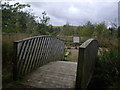
Footbridge access to playing field
From Moss Road, Rhynie.
Image: © Stanley Howe
Taken: 29 Aug 2011
0.04 miles
8
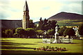
The Square, Rhynie
War Memorial, Rhynie Kirk and the Tap o' Noth in the background.
http://www.rhynie.net/
Image: © Colin Smith
Taken: Unknown
0.04 miles
9
Rhynie parish kirk
Built in 1823 on a north-south axis and extensively altered in 1889, when the spire was added to the north-east corner. C-listed (LB16034): http://portal.historicenvironment.scot/designation/LB16034 but hardly enthusiastically: "Of value only as the dominant feature of the village...".
Image: © Bill Harrison
Taken: 23 Sep 2017
0.04 miles
10
Octagonal clock tower, with spire
Part of the Parish Church in Rhynie; here viewed from outside 'fourteen' - the church hall on The Square.
Image: © Stanley Howe
Taken: 28 Aug 2013
0.04 miles