IMAGES TAKEN NEAR TO
Rhynie, HUNTLY, AB54 4AB
Introduction
This page details the photographs taken nearby to AB54 4AB by members of the Geograph project.
The Geograph project started in 2005 with the aim of publishing, organising and preserving representative images for every square kilometre of Great Britain, Ireland and the Isle of Man.

There are currently over 7.5m images from over14,400 individuals and you can help contribute to the project by visiting https://www.geograph.org.uk
Image Map
Images are licensed for reuse under creativecommons.org/licenses/by-sa/2.0
Notes
- Clicking on the map will re-center to the selected point.
- The higher the marker number, the further away the image location is from the centre of the postcode.
Image Listing (7 Images Found)
Images are licensed for reuse under creativecommons.org/licenses/by-sa/2.0
Image
Details
Distance
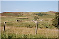
1
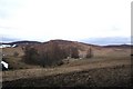
Tree Shelter by Longlands
Trees shielding the farm of Longlands with the Hill of Creagdrearg behind.
Image: © Andrew Wood
Taken: 21 Jan 2011
0.07 miles
2
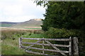
Along the edge of the wood towards Hill of Creagdearg
Image: © Des Colhoun
Taken: 14 Oct 2006
0.15 miles
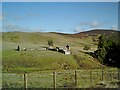
3
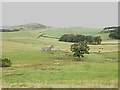
Ruined croft by Burn of Craig
With White Hill of Bogs in the left background.
Image: © Stanley Howe
Taken: 8 Aug 2013
0.19 miles
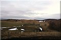
5
Ruin of Whitehillock farm
A ruined farmhouse and water mill beside the Burn of Craig. Canmore reference 106033: https://canmore.org.uk/site/106033/whitehillock .
Image: © Bill Harrison
Taken: 23 Sep 2017
0.20 miles
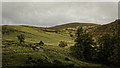
6
Whitehillock Ruins
The ruined farm of Whitehillock.
Image: © Andrew Wood
Taken: 21 Jan 2011
0.20 miles
7
Ruins of Whitehillock
From the Craig road
Image: © Stanley Howe
Taken: 3 Sep 2003
0.22 miles