IMAGES TAKEN NEAR TO
Fyvie, TURRIFF, AB53 8SB
Introduction
This page details the photographs taken nearby to AB53 8SB by members of the Geograph project.
The Geograph project started in 2005 with the aim of publishing, organising and preserving representative images for every square kilometre of Great Britain, Ireland and the Isle of Man.

There are currently over 7.5m images from over14,400 individuals and you can help contribute to the project by visiting https://www.geograph.org.uk
Image Map
Images are licensed for reuse under creativecommons.org/licenses/by-sa/2.0
Notes
- Clicking on the map will re-center to the selected point.
- The higher the marker number, the further away the image location is from the centre of the postcode.
Image Listing (11 Images Found)
Images are licensed for reuse under creativecommons.org/licenses/by-sa/2.0
Image
Details
Distance
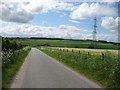
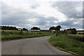
1
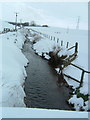
View along the burn towards Tifty
Arty picture in the snow. The burn runs through our land and down to join Tifty Burn
Image: © Bernie Allison
Taken: 5 Mar 2006
0.01 miles
2
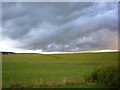
Towards Gourdas
Moody sky towards Gourdas/Tifty from Darnabo Croft
Image: © Bernie Allison
Taken: 2 Oct 2006
0.09 miles
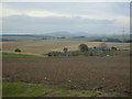
3
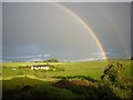
View from Darnabo Croft towards Darnabo and Monkshill
The Rainbows are a bonus !
Image: © Bernie Allison
Taken: 26 Sep 2006
0.10 miles
5
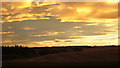
View towards Bennachie from Darnabo Croft
Lovely custard yellow sunset - you can just pick out the top of Bennachie on the right hand horizon!
Image: © Bernie Allison
Taken: 29 Jan 2007
0.15 miles
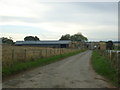
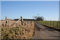
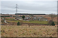
9
Darnabo Farm
The large farm of Darnabo with its access road.
Image: © Andrew Wood
Taken: 16 Jul 2020
0.24 miles
10
Burnside of Gourdas
A new house has been built alongside the traditional one at Burnside.
Image: © Anne Burgess
Taken: 27 Feb 2015
0.25 miles