IMAGES TAKEN NEAR TO
Cuminestown Road, TURRIFF, AB53 8RG
Introduction
This page details the photographs taken nearby to Cuminestown Road, AB53 8RG by members of the Geograph project.
The Geograph project started in 2005 with the aim of publishing, organising and preserving representative images for every square kilometre of Great Britain, Ireland and the Isle of Man.

There are currently over 7.5m images from over14,400 individuals and you can help contribute to the project by visiting https://www.geograph.org.uk
Image Map
Images are licensed for reuse under creativecommons.org/licenses/by-sa/2.0
Notes
- Clicking on the map will re-center to the selected point.
- The higher the marker number, the further away the image location is from the centre of the postcode.
Image Listing (8 Images Found)
Images are licensed for reuse under creativecommons.org/licenses/by-sa/2.0
Image
Details
Distance
2
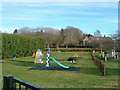
Fyvie Playpark
View from the school gates on a crisp January morning
Image: © Bernie Allison
Taken: 30 Jan 2008
0.03 miles
3
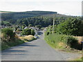
Heading down the hill to Fyvie
The C26S (Aberdeenshire) road heading south-west down the hill to the village of Fyvie.
Image: © Scott Cormie
Taken: 25 Sep 2021
0.03 miles
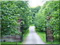
4
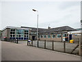
Fyvie Primary School
A sprawling 1960s and 1970s concoction replacing the early 19th Century school just down the street.
Image: © Bill Harrison
Taken: 19 Jun 2016
0.07 miles
5
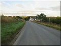
B9005 east of Fyvie
The B9005 heading west just outside the village of Fyvie.
Image: © Scott Cormie
Taken: 25 Sep 2021
0.23 miles
7
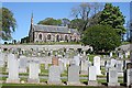
Fyvie Parish Kirk and Kirkyard
The church is dedicated to St Peter. It was rebuilt in 1808, repaired by James Henderson in 1863 and reconstructed with additions in 1903 by Alexander Marshall Mackenzie.
Image: © Anne Burgess
Taken: 7 May 2009
0.25 miles
8
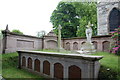
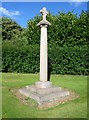
Forbes-Leith of Fyvie burial enclosure, Fyvie Kirk
An unusually elaborate enclosure just to the north-west of the main door.
Image: © Bill Harrison
Taken: 19 Jun 2016
0.25 miles